WELCOME!
If you are new to this blog you may want to start at the beginning.
If that is the case see archive to the right. Or feel free to start here.
Days 95 thru 98 map
CLICK TO ENLARGE

Runyak for Liberty Day 95, Sept. 17, 2015
It's been nearly 3 months since I left Waterford, NY. On that day, I was able to load Swiftee and leave before rain fell. The next morning, and for most of that day it rained heavily. Discouraged by my wife, who was with me for the trip, I did not continue, we returned home. I'm pretty sure had I been alone I would have jumped into and Swiftee and continued. My only worry now is by cutting the 4 day runyak to a 3 day runyak... will it make for an extra trip to NY to get to Lady Liberty?
Since Swiftee was molested on day 90, (when cooler and beer was stolen) I'm now leery of leaving anything in Swiftee overnight. So, when I arrived in Waterford Wednesday night, and instead of dropping Swiftee at the launch site, I slept in a McDonald's parking lot, got breakfast in the morning, then headed to Waterford Battery Park where I'd finished in June.
Arriving there and while preparing, one of Waterford's Finest pulled up to Swiftee and me on a bicycle. We had a lengthy discussion of my mission. I mentioned I did not like leaving anything in the kayak and asked how safe he thought Battery Park was. 'Officer Roy' was not overly keen of the idea of leaving valuables in the kayak either. He pointed out that there was a welcome center a short distance up the quay and that I could leave my cooler, paddle and dry bags there.
After securing the items at the welcome center I headed for Albany to begin my 10 mile run back. I found a boat launch near downtown Albany owned by Albany Rowing Club. The run began on the Mohawk-Hudson Hike-Bike Trail.
 It was a nice shady trail for the first few mile before breaking up at the city of Watervliet, twin city of Troy, just across the Hudson. While passing through the streets of Watervliet I enjoyed reading the many posters with photos on utility poles. Each honored the Waterford veterans. I thought to myself more towns should do the same. The next day while driving through Albany's sister city across the river, Rensselaer, I noticed they had done the very same thing.


ALL PHOTOS ENLARGE WHEN CLICKED

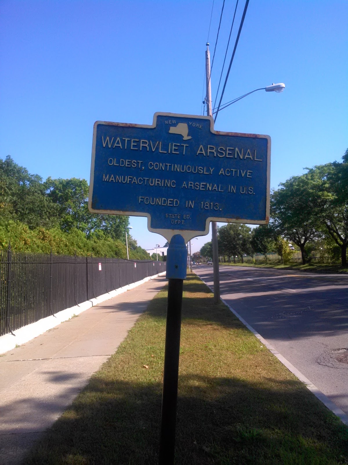
Another item of interest that caught my attention when passing through Watervliet, was the Watervliet Arsenal. Owned by the U.S. Army and is the oldest continuously manufacturing (cannons, mortars, and tanks) arsenal in the country.


 Lockers along the Mohawk-Hudson Hike Bike Trail

Albany Rowing Club Launch

 On the opposite side of the river from Albany was a marina. I watched as a boat slowly towed another upriver to a gasoline pump. As it dropped them off and pulled away I noticed the boat doing the towing was the state police. The police then headed back downriver.
A good half-hour later I saw a boat just sitting in the middle of the river not moving. I recognized it as the state police boat. Paddling by I raised my camera to get a picture. One of the police officers on board yelled that they wanted a picture also (must have read the sign of Swiftee's stern).
 I paddled over and spoke with them and offered my card.
 They pointed to a large black box next to them. It was some sort a radiation detector. One said, "We can tell you don't have any C4 in your kayak." From that I take it they might be working with Homeland Security. Their 'beat' extended about fifty miles from the Federal Lock down to Saugerties, a town I won't get to until my next trip.


 I wanted to linger at the launch park and watch the sun rise but it would be another twenty minutes so I hit the inclined road heading out of town shuffling. I certainly was noticing the climb from the launch up through the village, thus I say shuffling.


 The boat ramp, which accommodates yachts, was much larger than I'm accustomed, but as soon as I paddled beneath the dock I was off and moving rapidly.
Yesterday, battling the waves, my pace was nearly 25 minutes a mile. Today the waves were going south like my boat, and it only took 1:40 to paddle 7 miles to arrive back at Coxsackie Boat Launch. My average pace for the 7 miles, was an amazing 14:45 minutes per mile. Fastest pace of any of the 98 segments of the R4L Expedition. More amazing, the fastest paddling day happened on the same day as the slowest day of running. Never before has my running pace been slower than my paddling pace. Easy day for Swiftee, hard day for my legs.

 Because I started earlier and the speed of paddling, I finished and was out of the Hudson before 11:30 am. Packing up, I decided to go back to Shady Harbor for another shower before the 10 hour drive home.
Two rough wave days in a row on the Hudson. The second, favorable, but not the first. I plan to come back in October for another four days. If the river is this rough in September, I'm concerned and wondering what the colder month of October will be like.
Day 98 - 8.25 run, 6.9 yaked

Federal Dam seen from pathway in the village of Green Island
Arriving back to Waterford on foot I immediately retrieved my gear from the welcome center and launched and began paddling the Hudson from the mouth of the Mohawk-Erie Canal terminus.

Hudson River from the mouth of the Mohawk River
In less than 2.5 miles I was inside the very last lock I'd be passing through, the Federal Lock, which could be called Lock 1, for the first lock of the Erie Canal is Lock 2. The numbering is off because when the Barge Canal was being funded in the early 20th century, the state of New York was unsure if the first lock would be built by the federal government since it was on federal waters. Since the building of the Barge Canal began before knowing who would build it, the state numbered the canal locks using one as the lock on the Hudson. Federal government did build it and still operates it today, thus the lock numbering of the canal is sort of screwy. (Screwy also because there is no Lock 31 but there are two 28s: 28A and 28B.)
The first thing I noticed when entering the Federal Lock is it seemed twice and long as the Erie Canal locks.
I mile after exiting the lock I was paddling beneath an odd funky looking bridge. Named the Green Island Bridge, it is a vertical lift bridge that is seldom operated.

Near the bridge I passed a mural painted on the wall of brewery. I got excited thinking I'd come back and visit it later. Eventually, I was disappointed when discovering it was a pseudo-name for Brown's Brewery, one I had visited five years ago.

When I landed at the rowing clubs dock to finish, I cabled and locked Swiftee for the night, taking anything of value with me to the van. Except the van was over a quarter mile away. I hadn't park near the launch but a park, Corning Preserve just downstream. A park employee said I be better off to park there because parking tickets were issued after 90 minutes at the launch parking lot. When lugging the paddle and drybags I was wishing I hadn't listened to him.
Day 95 - 9.25 Run, 9.0 yaked
Runyak for Liberty Day 96, Sept. 18, 2015
I parked my van and began my run at Henry Hudson Park in the Township of Bethlehem. My run was mostly on state highway 144. I've grown accustom to running on trails so much I'm now spoiled. I now dislike having to run along highways. Once back to the city of Albany, I ran a mile or so along the downtown waterfront, again on the Mohawk-Hudson Hike Bike Trail.


I arrived at the Albany Rowing Clubs landing and retrieved my paddle and dry bags from where I left them. That would be inside lockers designed for paddles and such. The day before when running from and landing there I did not notice them. They were pointed out this morning by a couple women inside the fenced in rowing club compound. I asked how safe it was to leave my paddle and bags in my kayak. "Not that safe," one said. I asked in hopes I could leave them inside the fenced in area, that is when they showed me the lockers. I had no lock to put on the locker, but the hinges were so rusted, I had to pry the door open to put my belongings inside. Being that hard to get into I felt they were safe.
And they were. When I arrived back after running 9 miles, pried open the locker, got my paddle and bags and paddled off. In minutes I was passing by downtown Albany.


Albany Rowing Club Launch

Downtown Albany

A good half-hour later I saw a boat just sitting in the middle of the river not moving. I recognized it as the state police boat. Paddling by I raised my camera to get a picture. One of the police officers on board yelled that they wanted a picture also (must have read the sign of Swiftee's stern).


Ramp and dock at Henry Hudson Park
I finished the runyak by landing at Henry Hudson Park where there was a boat ramp and a dock. I prefer to parallel and roll out onto the dock rather than land at the ramp. I can stay dryer that way, and Swiftee's bottom doesn't get scraped. Lord knows I've had to patch his bottom enough as it is. It was before 2:30 so had much of the day left to explore the city.
One thing I did that evening is go to a brewery that I'd learned about the evening before, Druthers. It was the 499th brewery where I've drunk. If I had my druthers, my 499th would have been a new one that had just opened up in Holly, MI, Northern Oak Brewing. You could say I still had my Druthers.

Before going to bed, even though I was too full and had enough to drink, I had to at least stop and check out one other establishment. I had to because of the name (see photo). I just walked in looked around, went back to the van.

Swifty's of Delmar, NY
Day 96 - 9.00 run, 7.8 yaked
Runyak for Liberty Day 97, Sept. 19, 2015
Just after 7:00 am I left on foot and headed back to Swiftee, from Donavan's Shady Harbor Mariana in the town of New Baltimore, New York. I add 'state' for differentiation. You see, on day 30 I ran through New Baltimore, Michigan, located on Lake St. Clair. The first time I can recall the expedition passed through two towns with the same name.
A few miles into the run I run through the village of Coeymans, in the TOWNship of same name (the word 'town' in NY like in Ontario and maybe other states is short for township. In Michigan, where I live, a township is never referred to as a town.
I found the village unique, and strange looking. All buildings were very old and close to the rolling and winding, Route 144. I recall many similar linear looking towns of Ireland, but building there seemed in better shape. The town's odd name comes from the Dutchman, Barent Pieteres Koijemans, that obtained the "land patent" from what was then New Amsterdam, not New York


On the northside of "Koijemans" I ran across Coeymans Creek.
I wondered why it was called a creek when all other creeks I've been passing, and will be passing throughout the Hudson Valley, are called "kills" the Dutch word for creek.
From the moment I paddled out of Henry Hudson Park I new it was to be a tough paddle. Wind was coming from the south. It created waves going up river. Add to that the boat traffic, and it made for some rough, choppy paddling today. The seven miles took nearly three hours. 24:41 per mile pace is one of the slowest I've experienced during the 97 days of adventure. I never put the spray skirt on Swiftee today so waves weren't as daunting as on Lake Erie but I did not stay dry. Several times water came over the bow and dampened me.

On the river today I passed what looked similar to the Great Lakes freighter. Not sure what kind of ship it was, but it was definitely the biggest ship I'd seen since paddling by the Welland Canal back on Day 50.
My aching arms were glad to make it into the havenly Shady Harbor Marina. Also, it was great finding a bath house at the marina for I felt the need of a shower.

Day 97 - 8.00 run, 7.0 yaked
Runyak for Liberty Day 98, Sept. 20, 2015
I got up earlier than the previous three days because I wanted to finish early for I had a ten-hour drive home. I drove to Coxsackie Boat Launch in the village of Coxsackie in the TOWNship of same name.


The entire run of over eight miles seemed to be uphill or downhill. Aside from being exhausting it was a beautiful run. On the paved farm road seldom did a vehicle pass. I'm now getting close to the Catskill Mountains, this area could be called the foothills.


Running by one farm, a horse spotted me from a distance and came running to the fence to meet me. Never has a horse react to me that way before. I had to stop and talk to him. Would've been nice to treat him with an apple or something but the best I had to offer was grass I plucked from the ground. He wasn't amused and said as much by snorting.


The last mile of the run was through the Town of New Baltimore. From there I got a great view of yachts
lining the slips of Shady Harbor. I could barely spot little Swiftee, but doing so I felt relief that the hilly run was about over. Because of the hills, and having ran over 26 miles the previous three days, the average pace for the run ended up being 16:08. The slowest pace of any day of the R4L Expedition.


Yesterday, battling the waves, my pace was nearly 25 minutes a mile. Today the waves were going south like my boat, and it only took 1:40 to paddle 7 miles to arrive back at Coxsackie Boat Launch. My average pace for the 7 miles, was an amazing 14:45 minutes per mile. Fastest pace of any of the 98 segments of the R4L Expedition. More amazing, the fastest paddling day happened on the same day as the slowest day of running. Never before has my running pace been slower than my paddling pace. Easy day for Swiftee, hard day for my legs.


Two rough wave days in a row on the Hudson. The second, favorable, but not the first. I plan to come back in October for another four days. If the river is this rough in September, I'm concerned and wondering what the colder month of October will be like.
Day 98 - 8.25 run, 6.9 yaked


