MAP: Day 1 to Day 113

Runyak for Liberty Days 109 to 113

If you are new to this blog you may want to start at the beginning.
If that is the case see Blog Archive to the right. Or feel free to start here.
In the spring of 2009 I coined the term Runyaking. Not easily explained but in the simplest terms: Runyaking: Placing a kayak by a waterway, and driving a distance down the waterway and parking vehicle and running back to the kayak then paddling to the vehicle. If one wishes to explore the waterway further one can repeat the segment just mentioned from where they left off.
I've completed 113 days of runyaking from the source of my home watershed, the Flint River. By using waterways of Michigan inland rivers, the Great Lakes and connecting rivers, St. Clair, Detroit, and Niagara, the Erie Canal and Hudson River, I've arrived at Yonkers, NY, about 20 miles from Statue of Liberty on 22nd, 2017.
In the first four years, I was attempting a solo runyak the Flint source to Niagara Falls. Once reaching that goal I wrote a book, The Runyaker's Journey. This blog only covers the adventure from Niagara to the Statue of Liberty. To read that book, please buy the awesome e-book. It is only $4 and can be purchased many places online. This is the Amazon link. Once at Niagara I did not want to quit so I decided to keep going until reaching Lady Liberty.
Those who have followed me over the years know I have done fundraisers for cancer research (V Foundation for Cancer Institute, American Cancer Society, Dana Farber Cancer Institute, American Cancer Institute.) When I began my runyaking to Niagara Falls and now Statue of Liberty it never crossed my mind to do another. Yet, along my route, people have stopped me and asked if there was a cause for which I was raising money. So, I decided to go looking for a good cancer research institute so when asked I can say "YES." In my search, the Cancer Research Institute, was always one of the highest rated and why I chose to go with them. My friend Corky Meinecke, who died of cancer in 1997 is still the spirit that drives me. If you are following my progress as I Runyak for Liberty and feel you'd like to make a special pledge to someone who has fought cancer, please do. You will be in my thoughts as I runyak to the Statue of Liberty. You can donate at: Riley's CRI pageRunyak for Liberty Day 104, September 15, 2016
Runyak for Liberty Day 109, May 20, 2017
Remember, clicking on photos will enlarge them.
I kissed my wife goodbye at seven in the morning and began what would be a twelve hour drive before arriving at a 24 hour McDonalds near Peekskill. Not for food, but so I would have wi-fi for the evening. I would have made it in ten hours but made stops at five breweries. Breweries are a backstory to my journey, and find it hard to pass them in route. Not that I drank much, most places just a 5-oz glass, enough to say I drank at the particular brewery.
Waking up on RFL day 109 temperature-wise, it was already in the 70s. Before the day was through it would reach 98 degrees. The hottest day of the 109 runyak days that I can remember.
I drove from McDonald's to Cold Spring, where I debarked last September, then prepped Swiftee for the seven mile paddle, that I hoped would start at 10:00 am., but would be after 11:00 am because of problems.

The biggest problem was, when I drove to where I'd end paddling but start running, Fort Montgomery, I could not park the van, there was a gate blocking entry. The park would not open until 9:00 am, another hour and a half. Grrr! I drove away looking for the nearest place to leave the van for 5 hours or so. I found additional parking for the historic fort a quarter mile away. I walked from there to where Swiftee and I would be landing later. I limit my running to only what is needed according to the rules of runyaking (which I made up). I'd be running close to 50 miles in the next 5 days, don't want to waste running muscles.

It was during the walk back to where I'd begin running, that I saw, and took this photo, ruins of the barracks of old Fort Mongomery.
It was getting close to 8:00 am when I began my run back to Cold Spring, a half hour behind caused by the parking snafu. I really wanted to begin the paddle by 10:00 am, knowing that would give me two hours of tidal advantage (low tide was about noon).

During the Revolutionary War, Fort Montgomery was a defensive hold against British ships trying to navigate up the Hudson. It, was one of the locations, chains were strung across the Hudson to stop British ships. The chains were forged at the forge across the river at Cold Spring, my launch point. Just upriver from Fort Montgomery is West Point, where the "Great(est) Chain" was positioned. The fort there at West Point was named Fort Arnold, after THAT traitor. It was renamed Fort (James) Clinton for obvious reasons. I'm seeing much Revolutionary history where I am, and will be runyaking.

In this photo, left of the rail bridge is Popolopen Creek, right of it is the Hudson River. Fort Montgomery would be in the vicinity of the the bare spot in the woods, upper right. I am taking this photo from Bear Mountain Bridge, a mile from where he run began (near the pedestrian bridge barely seen below the arched bridge). In the mile run I've elevated 200-feet.

This tranquil pretty picture was taken from the middle of the Bear Mountain Bridge looking north to the Hudson Highlands, where West Point is (on the west) and Cold Spring around the bend on the east. It's a rarity to paddle on such placid waters.

Although the Robinson House is no longer, I ran past a sign noting the location near Garrison, NY. It's said Benedict Arnold fled from his wife and child to escape on the British ship Vulture.... Love the history of the area.

This is the entrance of Saint Basil Academy, a school for at-risk youths. It was of interest to me because it once was Eagle's Rest, the estate of Jacob Ruppert who created the New York Yankees dynasty of the 1920s and 1930s. Babe Ruth, Lou Gehring and the rest of Murderer's Row all spent time at here at the owner's mansion.

Near the end of my 10 mile run, there was gap in the Highlands, where across the Hudson (out of view) looking west I could see West Point.

This is Swiftee and a Hudson Highland peak, just before launching on day 109. I was an hour later launching than expected, but still an hour ahead of low tide. I was thankful to get any favorable paddling.

A northerly view of the Hudson Highlands, I'd be paddling the opposite way

West Point's Eisenhower Hall to the left and Fieldhouse to the right.

Thayer Hall of West Point from the river resembled a fortress

This is photo of the Army's Navy!

I counted 9 Army 'sailors;' can you believe that?

Bear Mountain Bridge built in 1924. Oldest bridge south of Albany.
My exit from the river can't be seen, but is just before going under the bridge. I'd veer off, up the mouth of the Popolopen Creek.

A man with a Scottish brogue walking his dog took this photo. Besides the three bridges seen, the pedestrian one, above my head, the rail trestle just above water, and the Bear Mountain Bridge, there is another in the direction I am looking. With this added non-Riley photo, of the missing arch bridge, all four can be seen.

When finishing Day 109 the temperature was way over 90. I had to find relief from the heat.
One day down, four to go. The run was excruciating because of the heat, with a pace of 15:30/mi. I worried about having to run four more days, (I would find out the following day's runs would be better.) After the run, and when I began paddling, I was so tired from the run, my arms were refusing to do their job assignment. They were in oxygen debt just as my leg. Thank goodness I had some tide moving me or I would have not made it. I ended up paddling 2 hours, well after I figured tide would be reversing, but I never felt it, The average pace was 17:30 per mile. Better than average pace for most rivers I've paddled.
So hot was the rest of the day, I had to find a motel to get some relief. Not far from the USMA at West Point I found a nice reasonable priced one. Only the second time in my solo trips I've not slept in my van. Last time, was Day 87, at Little Falls, NY. Quite different that day, then it was because of October cold and wind.
Once on the 9 mile run I watched the gps course on my smart phone closely. I'd be running through Peekskill, and any wrong turn would cost extra miles on my legs. Once out of Peekskill, about halfway, I knew the rest of the route. The rest of the way would be a winding mountain road with no shoulder to run on. I felt a little unsafe. Before heading into the danger zone, I stopped at a convenience store, drank a bottle of Gatorade, same as I had the on the run the day prior. I didn't feel the need for it as I did the day before, which is good. Yesterday I was thinking each day of running would get worse.
The previous day's run also had been on a winding 'mountainy' road. Both days I saw cyclist. I was leery running the roads, no way would I ride a bike. When I could, I crossed the road at sharp bends so cars would have a longer line of sight before seeing me. Not once did anyone honk horns like I was a crazy s.o.b. for running the winding road, which surprised me.
I stopped running when I reached the Bear Mountain Bridge and walked the rest of the way to the kayak, (over a mile.) The day before I ran the opposite way from Ft. Montgomery over the bridge, so the distance had been covered already by runyaking rules (that I made up). I've come to do this "walking" thing since the first days of the Erie Canal. Running the same thing twice just adds superfluous miles to the total RFL miles. My legs don't need it, and it just pads the total mileage.
Bear Mountain Bridge is where the Appalachian Trail crosses the Hudson on its way from Georgia to Maine. While walking across the bridge I had an 'aha' moment. A friend, Marit
Janse, walked the entire AP trail in 2004, the year I retired from GM. I envied her and wanted to do a special journey myself. I bought Swiftee a couple months after her finish, and began exploring the Flint River from its beginning to the Saginaw Bay the following spring. The following three years, I did the same for all major rivers of the Saginaw Valley: Tittabawassee, Shiawassee, and Cass. Those four years served as my apprenticeship for daring to do the Runyak for Liberty. Today on the RFL, my path crossed with Marit's Appalachian path. Of course, I had ran it the previous day, following her footprints, but today, going the opposite way, they crossed.

I launched on Day 110 and headed out into the Hudson for what would only be a 6 mile paddle, I had to paddle less than 1/4 mile to the mouth of the Popolopen Creek. I really was hoping I'd paddle under the trestle when there as a train overhead. I missed the train by several strokes.


 For what seemed like a mile, running in the morning, I passed the Indian Point Energy Center. In the final miles of paddling, I had to get around the point, that produces nuclear energy. IPEC owned my Entergy is scheduled to close in 2020-21.
 I've been finding landings by using the Hudson River Greenway Water Trail map.
Arriving at their proposed dock at Verplanck Point I found it very difficult to debark. The deck was too high. Using the boulders, I managed to get out of Swiftee and get him to higher ground. Minutes later, a hundred yards further, I saw a gravel beach, where I was supposed to land. Arrgh! Oh well, on Day 111, I will use it for a much easier launch.
 I had much time on my hand after RFL Day 110 landing at 1:00 pm. So, from Peekskill, I took a 40 mile ride (south) on the Metro North, into Manhattan. I was there during rush hour. I was hoping to visit a brewery, but could not find one. My phone went dead on the ride in. Before leaving Grand Central Station, I bought a portable charger, which was supposed to be pre-charged. Yeah right! About two minutes worth. I tried two other places, one a Staples, all were the same, basically dead. I was smart enough the second and third time to check the charge before leaving.
Having no smartphone in Manhattan is crazy, how can one maneuver Gotham without one? Of course, I never heard of a smartphone the previous three times there, and I managed just fine. Back then...at least I carried a map and camera. Today, I was able to take this lone photo above, before the camera shut down. I did go to a brewery though, Heartland, near Times Square, that I had been to 15 years ago. Nobody there could help me locate another brewery, so my business in Manhattan was over. I headed back to Peekskill.
That night I slept at the same 24-hour McDonald's as the first night, the temperature had dropped significantly during the day, so much, it was cold at times during the night in the van.
Runyak for Liberty Day 110, May 21, 2017
When I woke up on Runyak for Liberty Day 110, it seems strange being in a motel room. When I left the room, I ask the desk clerk where the ice machine was. She said she had ice in bags and brought me one. It was in a Glad bag, enough maybe to chill a bottle of wine. I was looking for a big bag. She asked, is that enough? Knowing I'd need ten of her bags, I just said yes, and left to buy some on the way. I was irked enough that I drove past Fort Montgomery, Swiftee's location, without thinking, paid the $1.50 toll to the troll, to get across the Bear Mountain Bridge. I was across the Hudson and two miles from Swiftee when I realized I hadn't prepped the kayak before heading to where I'd be running from, Verplanck Point. I had to turn around, head for Swiftee. Which meant I had to pay the bridge troll once again. Arrgh!Once on the 9 mile run I watched the gps course on my smart phone closely. I'd be running through Peekskill, and any wrong turn would cost extra miles on my legs. Once out of Peekskill, about halfway, I knew the rest of the route. The rest of the way would be a winding mountain road with no shoulder to run on. I felt a little unsafe. Before heading into the danger zone, I stopped at a convenience store, drank a bottle of Gatorade, same as I had the on the run the day prior. I didn't feel the need for it as I did the day before, which is good. Yesterday I was thinking each day of running would get worse.
The previous day's run also had been on a winding 'mountainy' road. Both days I saw cyclist. I was leery running the roads, no way would I ride a bike. When I could, I crossed the road at sharp bends so cars would have a longer line of sight before seeing me. Not once did anyone honk horns like I was a crazy s.o.b. for running the winding road, which surprised me.
I stopped running when I reached the Bear Mountain Bridge and walked the rest of the way to the kayak, (over a mile.) The day before I ran the opposite way from Ft. Montgomery over the bridge, so the distance had been covered already by runyaking rules (that I made up). I've come to do this "walking" thing since the first days of the Erie Canal. Running the same thing twice just adds superfluous miles to the total RFL miles. My legs don't need it, and it just pads the total mileage.
Bear Mountain Bridge is where the Appalachian Trail crosses the Hudson on its way from Georgia to Maine. While walking across the bridge I had an 'aha' moment. A friend, Marit
Janse, walked the entire AP trail in 2004, the year I retired from GM. I envied her and wanted to do a special journey myself. I bought Swiftee a couple months after her finish, and began exploring the Flint River from its beginning to the Saginaw Bay the following spring. The following three years, I did the same for all major rivers of the Saginaw Valley: Tittabawassee, Shiawassee, and Cass. Those four years served as my apprenticeship for daring to do the Runyak for Liberty. Today on the RFL, my path crossed with Marit's Appalachian path. Of course, I had ran it the previous day, following her footprints, but today, going the opposite way, they crossed.

I launched on Day 110 and headed out into the Hudson for what would only be a 6 mile paddle, I had to paddle less than 1/4 mile to the mouth of the Popolopen Creek. I really was hoping I'd paddle under the trestle when there as a train overhead. I missed the train by several strokes.

Going under the Bear Mountain Bridge, I noted it was the third to last bridge I'd paddle beneath before reaching the Statue.
The peak that BMB seems to cave into is Anthony's Nose. The bridge road actually T's there and goes north and south. Wondering who 'Anthony' is I searched Wikipedia and got this for an answer, "The peak has been known as Anthony's Nose since at least 1697, when the name appears on a grant patent. The eponymous Anthony may be St Anthony, as a rock formation called 'Saint Anthony's Face' existed on Breakneck Ridge nearby before its destruction by quarrying."

It was an fast and easy paddle today, averaging under a 15 min. pace. The second mile was 11:29 pace! The paddle turned out to be the easiest day of the 5 days of kayaking. I enjoyed the easy day by drinking some M-43 New England style IPA from Old Nation Brewery in Williamston, MI, my new favorite Michigan IPA.


Arriving at their proposed dock at Verplanck Point I found it very difficult to debark. The deck was too high. Using the boulders, I managed to get out of Swiftee and get him to higher ground. Minutes later, a hundred yards further, I saw a gravel beach, where I was supposed to land. Arrgh! Oh well, on Day 111, I will use it for a much easier launch.

Having no smartphone in Manhattan is crazy, how can one maneuver Gotham without one? Of course, I never heard of a smartphone the previous three times there, and I managed just fine. Back then...at least I carried a map and camera. Today, I was able to take this lone photo above, before the camera shut down. I did go to a brewery though, Heartland, near Times Square, that I had been to 15 years ago. Nobody there could help me locate another brewery, so my business in Manhattan was over. I headed back to Peekskill.
That night I slept at the same 24-hour McDonald's as the first night, the temperature had dropped significantly during the day, so much, it was cold at times during the night in the van.
Runyak for Liberty Day 111, May 22, 2017


Runyak for Liberty Day 112, May 23, 2017



As mentioned earlier, there's a lot of Revolutionary War markers on both sides of the Hudson in the area I'm runyaking. Where I launched on Day 111, was also the launching spot of the pivotal moment of the Revolution. George Washington made a decision to abandon all New York operations and head to Yorktown, VA. The victory there was the last major battle of the war. So, here in the summer of 1782, Washington commanded troops to cross the Hudson from Verplanck Point to Stoney Point on the west side and move south, bypassing NYC which was controlled by the British
I was awed when looking at the portrait on this monument. I was seeing the same identical peeks across the Hudson that I was looking at Verplanck Point. It was a "standing in Washington's footsteps" moment. I prepped Swiftee yards away from the monument, then drove to Ossining, NY and ran 10.5 miles back to the kayak. The run was noticeably less hilly than the previous days, a sign that I am out o the Hudson Highlands.
I was awed when looking at the portrait on this monument. I was seeing the same identical peeks across the Hudson that I was looking at Verplanck Point. It was a "standing in Washington's footsteps" moment. I prepped Swiftee yards away from the monument, then drove to Ossining, NY and ran 10.5 miles back to the kayak. The run was noticeably less hilly than the previous days, a sign that I am out o the Hudson Highlands.

South if Verplanck Point, and out of the Hudson Highlands, the
river dramatically widens. I'm in the Tappan Zee (Tappan Sea) It is more than 3
miles wide in several places. Last time my water route was this wide was when
the Erie Canal crossed Lake Oneida, which was at times 5 miles wide. I had
difficulty crossing Oneida because of waves similar to ones encountered on the
Great Lakes. Recently, knowing the Tappan Zee had to be navigated, I was
concerned about rough water, especially combining the tide into the equation. Today it was not a problem.


My landing today would be yards away from Sing Sing
prison in Ossining, NY. I'm paddling toward it in this picture.

This is where
Swiftee spent the night of Day 111, at the dock and launch of the Ossining Boat and Canoe Club. Unknowingly, I arrived at OBCC the
day before Commissioning Day, "a time honored tradition
which celebrates the opening of the new sailing season," Which OBCC holds once a year, third Sunday in May. The
hospitality of Ossining Boat and Canoe Club is above any other boat club I've
come across. Quite the opposite from on Day 105, I contacted the Pirate Canoe
Club south of Poughkeepsie for permission to land and launch, and they
basically told me to buzz off, we're private. The OBCC members were hard at work
gussying up the the property for Commissioning Day. One female member, Meadows,
invited me in to eat lunch with other members, Peter, Mike and Susan. I believe
it is only the second time I was fed while on the entire adventure. The last
time was on the Erie Canal on Day 70 at Lyons Fire Dept. I met Bob Stopper that
day, and he took me into the fire hall where they were having a Sunday chicken
dinner, and bought me one.
I bid the members of OBCC
goodbye after asking if it would be alright to cable and lock Swiftee to a park
bench. They said fine, and then Meadows even showed me the shower room, saying
I could take one. I didn't, but said if the offer still stood for the following
day I might. She said yes, but there would be much going on with it being
Commissioning Day
Awaking from the confines of my van at Ossining's McDonalds I drove to where I left Swiftee, the day before. There he was... uncabled and locked. Something interrupted me the day before and I forgot. Good thing it was at the boat and canoe club, a semi-secure location.
The run back to Swiftee in Ossining was less than 10 miles but delightful. It began at Matthieson City Park of Irvington, NY. Before reaching Swiftee I'd run through Irvington, Tarrytown, and Sleepy Hollow, an area heavy in the history of Washington Irving (1783-1859).

In my steep uphill run, out of the river valley, I ran past this statue of Rip Van Winkle, Washington Irving's most famous literary character.
The name Irvington was established in 1854 to honor Irving who was still living in Tarrytown, the next town north. The new name came about when two villages of Dearman and Abbotstown combined.

Yes, there really is a Sleepy Hollow, not a fictious town but a quant village just north of Tarrytown where Washington Irving actually lived.
Most of Irving's years were at his mansion Sunnyside. Another mansion in Tarrytown is Kykuit built by John D. Rockefeller. While running though the river towns of Irvington, Tarrytown, and Sleepy Hollow (I'm not sure how the area ranks by wealth), I got the feeling like I was back in Michigan, runyaking the Grosse Pointes on Lake St Clair.

I passed a large cemetery in Sleepy Hollow. I did not know it at the time but several famous people are buried there, besides Irving, Andrew Carnegie, Walter Chrysler, Samuel Gompers are interred there.

Paddling out of Ossining my first view on the river was Sing Sing, one of the most infamous prisons in the United States. I first learned about Sing Sing from watching the Three Stooges when a kid. Seems in many episodes that is where they were, or they were being "sent up the river." That term for "go to prison," originated here, or actually in New York City where convicts were sent up the Hudson to Sing Sing.
I'm paddling to Irvington, which is about 9 miles. The tide would not turn against me until about 3:00 pm so my paddle pace again was about 15min/mi.


About two thirds of the way, I went under the second to the last bridge of the RFL. And the longest, 3.5 miles, Tappen Zee Bridge.
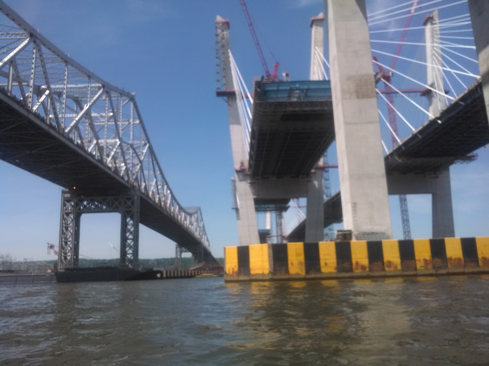
Make that a bridge and a half. A new TZB which began construction in 2013 has a projected completion of April of 2018. The new double span twin bridge, right will replace the cantilever bridge, completed in 1955, on the left.

Reverse angle looking east, the side of the river I've been runyaking since Poughkeepsie, a 100 runyaking miles ago. The bridge is where the New York Thruway, beginning in Buffalo, and ending in NYC, crosses the Hudson. Pedestrians are not allowed, so I will remain on the Hudson's eastside.
The Hudson River is the widest at Tappan Zee. Why I wondered was the bridge built at the widest spot? If you are curious enough also, read a short article, "The Mystery Of Tappan Zee: Why Build A Bridge Where The River's Wide?" Briefly, MONEY, it would cost more, but in the end it would make more money.
 Once beyond the TZB I had a clear look down river. What I saw caused much emotion. I could see the New York City skyline. The first thing I did was go Facebook Live with my amazement. After 112 day of runyaking, to me, it was the most glorious horizon ever.
 New York City skyline, The Palisades of NJ on the right.

 I landed at Irvington's Matthieson Park about 1:00 pm. Early enough I thought of doing another segment and end in Yonkers. You see, the following day, Monday, is forecasted to be a rainy day. My thoughts were, if I got the Monday's segment in today, and it was raining tomorrow, I'd just head for home, since I did get to Yonkers, where I hoped to finish the trip.
To do this, I wanted to reverse the runyak order, kayak first and run last, mainly because the tide would soon be turning against me.
I switched into high gear, for I had to plant the van at JFK Marina in Yonkers 6 miles downriver. While going to the van, I passed a teen at the park gate taking payments to enter park entrance. I told him I'd be returning to kayak, and asked if I had to pay. He said Irvington residents were free, others pay. He knew I wasn't a resident, but said he'd let me in, adding, "I can't charge you, not with that cool hat and all."
The Hudson River is the widest at Tappan Zee. Why I wondered was the bridge built at the widest spot? If you are curious enough also, read a short article, "The Mystery Of Tappan Zee: Why Build A Bridge Where The River's Wide?" Briefly, MONEY, it would cost more, but in the end it would make more money.


To do this, I wanted to reverse the runyak order, kayak first and run last, mainly because the tide would soon be turning against me.
I switched into high gear, for I had to plant the van at JFK Marina in Yonkers 6 miles downriver. While going to the van, I passed a teen at the park gate taking payments to enter park entrance. I told him I'd be returning to kayak, and asked if I had to pay. He said Irvington residents were free, others pay. He knew I wasn't a resident, but said he'd let me in, adding, "I can't charge you, not with that cool hat and all."

Never did I ever think a free hat, I got from Short Brewing Company, would come in this handy. Paying would have saddened me. Never yet have I had to pay for parking, or launching, or park entry. In 112 days, have come close a few times, but so far, not a cent.
I drove to the JFK marina, parked the van and then... cycled back! CHEATER? Biked back? Not to worry I will eventually run from JFK to Irvington, but right now I was in a hurry to start kayaking, knowing I'd be bucking the tide to get back to JFK landing, and it would be evening.
On this trip, for the first time, I brought the bike. The last two trips I could have used a bike, I had to walk back to vessel and vehicle Oct 2015, and Sept. 2016, took a ride back to Swiftee after a run. Not to worry, runyak rules were followed every time, mainly being, every inch of the way from very beginning, has be covered by running and kayaking.
Back to Swiftee, I locked the bike up, hopped in Swiftee and paddled off.
Early in the day I saw the forecast, that the wind would be over 13 mph in the afternoon, but was hoping for the best. The first mile was 25 min/mi, second, 30 min/mi, and by the third it was 37 min./per mile (now tide is turning) plus waves were splashing over the bow. With three miles to go I was concerned enough to look for safe harbor. Helping to make that decision, wife, and friends had been posting me, "be safe." I obeyed. Long ago I was concerned about this part of the Hudson, The Widest Section. Now, in the Sea, yet with plenty of experience with wind and waves, the paddling was a little scary.
I ducked into Tower Ridge Yacht Club for protection against the growing waves. I no sooner grabbed docking poles to steady Swiftee, still bouncing from wave action, when a Yachty began screaming at me to get out of his club. I'd never been treated this poorly since the uppity, hoity-toities of Lake St Clair's, Grosse Pointes.

Tower Ridge Yacht Club
If thinking I'm not being fair, I will add the Club has history of turning noses up at myself and other riff-raff. I found this document written over fifty years ago, telling how nice, and clean, and unpolluted it was "when there were no foreigners (Slavic factory workers) to monopolize the place, and no fences were needed."
I stayed despite being seen as a tresspasser, and told to leave. I'd take my chances, thinking police, if called, would be sympathetic to the dangers.
In 15 minutes Swiftee was bobbing less. I decided to get to the next safe haven (hopefully a friendier place). I didn't have to paddle far, just another 3 football fields. I landed at Kinnally Cove, a city park of Hastings-on-Hudson, that the cities website explained had picnic tables, benches, and a "kayak launch." Gee, that would have been nice to know, something Hudson River Greenway Water Trail might want to add to there river map?

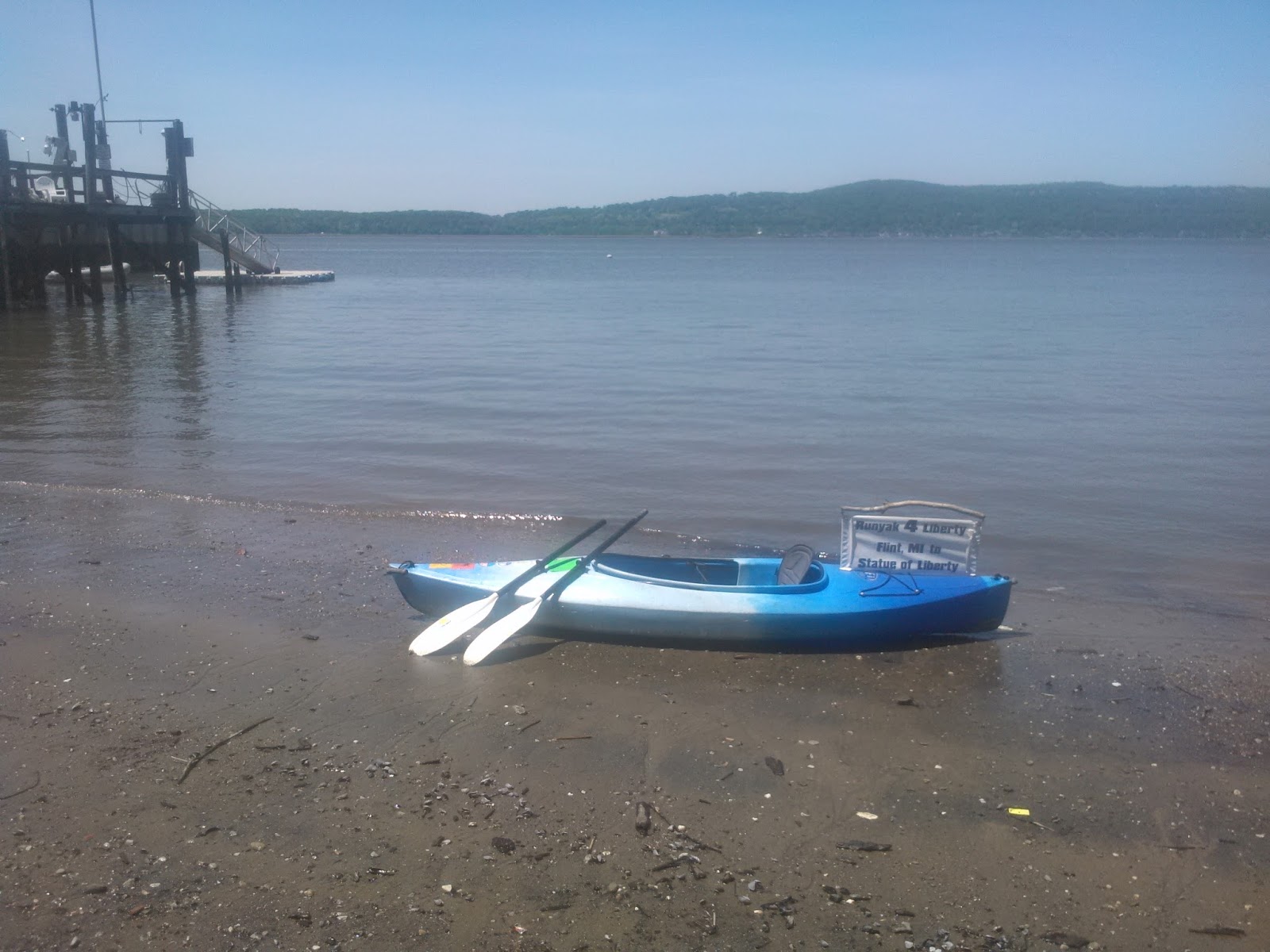
I landed among park-goers, many staring (the Flint MI sign on the stern?) I was wasn't sure if again I was trespassing. I asked onlookers if it was a city park, they said it was. I was relieved, then got out of Swiftee, and dragged him out of the water, wondering, "now what do I do?" I was 4 miles from my bike and 3.5 miles from my van. I'd brought my bike to avoid situations like this, and now I'm still in a pickle. Arrgh.
When assessing the situation, a curious lady came over and asked if I really had paddled from Michigan. Assuring her I had, I explained my quest, adding I now I needed to get to my van at JFK Marina. She said she'd gladly take me to it. I learned her name was Eva. Unlike all others who have helped me over the years, I never got her last name, so I can't continue thanking as I do others in my journal.
I gave her a final thank you, got into my van and drove back to where Swiftee was. Was I done for the day? No, I still had not run the "Hastings back to Irvington" section (where the bike was). Not until an hour of running and a 1/2 hour of biking back, was the day's two runyak segments complete.
When leaving home, I wanted to reach Yonkers, but looks like I fell short. Rain is still forecasted for most of tomorrow, Monday.
Slightly disappointed, I decided to get go get a beer and steak at Yonkers Brewing Co. in celebrating what I did get done in four days. I left Swiftee, cabled and locked at Kinnally Park, and headed for Yonkers. Afterward, I found a 24 hour McDonalds where I'd sleep, get up early, go get Swiftee, and make the long drive home.
Runyak for Liberty Day 113, May 24, 2017
The rain started in the middle of the night and kept me awake quite a bit. When after 5:00 am and awake, I decided it was time to head home. When driving back to Hastings to fetch Swiftee, it stopped raining.
As I was uncabling Swiftee, I looked out at the river. Like a siren it was calling me. Just a 3 mile paddle and a 3.5 mile run and my goal of getting to Yonkers on this trip would become reality.

The impulse overtook me. With no prep, or going through a checklist, as I always do, in running clothes, I grabbed the paddles, jumped into Swiftee, (wearing life vest) and took off.
Steady paddling at a slow 27:30 pace (against the tide? I never checked). I landed at JFK Marina after being in the water for 1:22 minutes. Never did it rain.

The Palisades from Hastings-on-Hudson. Not as spectacular as I hoped because of dismay weather.

Last shot of NYC skyline near where I left off Day 113.
Wanting to get the run in before more rain, I locked up Swiftee and headed off.
The first and last mile, of every run on the Hudson since Albany is very steep. Baby running steps to get out of the river valley, giant steps running back to the river. Out of Yonkers, was no different. I trudged upward until finding a trail, a very flat trail.
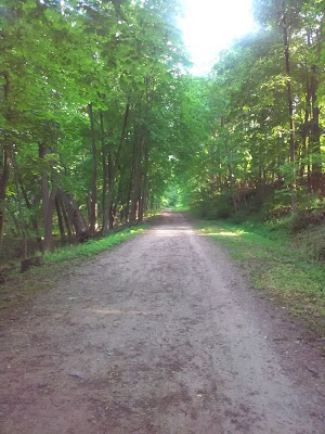
The trail is a marathon length (26.2 mi.) lineal New York State Park, that runs from Bronx/Yonkers border north to Croton Dam. The Old Croton Aquaduct trail follows the aqueduct path that began bringing fresh water to NYC back in 1842.

I've been biking and running the Old Croton Aquaduct Trail since Ossining whenever possible. Google Maps walking direction put me onto it. I did not know about it, but it sure beats running on Route 9 (Broadway) when available.
The rain held off, I finished the run drove back got Swiftee, loaded him and headed for home, via Manhattan and the George Washington Bridge. When crossing, I thought about my last trip when I'd be running over it. It was raining once again, and for hours. I caught a (cloud) break, and was content.


